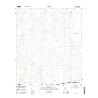
2016 Map of Putnam North
USGS Topo · Published 2016About this map
Putnam anchors the southern edge of this landscape, where the primary east-west transport corridor of the I-20 access roads meets a network of rural county routes. The terrain is defined by a dense web of ephemeral drainage systems, including Live Oak Cr, Lovelady Cr, and Battle Cr, which carve through the Callahan County countryside. In the northeast, Mission Mountain provides a significant vertical landmark, accompanied by the small Mission Mountain Airport. To the west, the Hart Cem near Sheep Cr offers a specific point of interest for genealogists tracing local family history. The map illustrates a rural Texas environment where settlement remains concentrated along the southern highway corridor while the northern sections are primarily divided by ranch and county roads like Co RD 312 and Co RD 304.
Find a feature on this map
34 named features on this map. Tap any name to fly to it.
Don’t see what you’re looking for? This feature index may not catch every label — zoom into the map to look around manually.
Map Details
Editions of this 2016 Putnam North Map
This is the sole edition of this map. No revisions or reprints were ever made.
Other maps of this area

1892 · Albany
USGS Topo · 1:125,000

1893 · Albany
USGS Topo · 1:125,000

1931 · Baird
USGS Topo · 1:125,000

1932 · Baird
USGS Topo · 1:125,000

1954 · Abilene
USGS Topo · 1:250,000

1958 · Abilene
USGS Topo · 1:250,000
1965 · Snyder Lake
USGS Topo · 1:24,000

1965 · Indian Knoll
USGS Topo · 1:24,000
1965 · Moran
USGS Topo · 1:24,000

1966 · Scranton
USGS Topo · 1:24,000