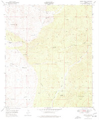
1949 Map of Putnam Wash
USGS Topo · Published 1977About this map
Cactus Hill Ranch and Tunnel Ranch anchor this arid landscape in the northern Tortolita Mts, where survival and settlement depend entirely on a scattered network of water sources. The 1949 terrain is defined by its drainage systems, most notably Putnam Wash, Bloodsucker Wash, and the southern Camp Grant Wash. These seasonal waterways are supported by numerous named wells and tanks, such as Beehive Well, Yellowjacket Well, and Cowhead Tank, which reflect the ranching infrastructure of the mid-twentieth century. An underground pipe line cuts through the desert floor, suggesting the industrial efforts to move resources across this high-elevation environment dominated by Antelope Peak. Researchers can trace the placement of remote outposts like Palmer Well and the secluded Putnam Spr during an era of transition for Pinal County ranching.
Find a feature on this map
22 named features on this map. Tap any name to fly to it.
Don’t see what you’re looking for? This feature index may not catch every label — zoom into the map to look around manually.
Map Details
Editions of this 1949 Putnam Wash Map
2 editions found
Other maps of this area

1911 · Winkelman
USGS Topo · 1:125,000

1913 · Winkelman
USGS Topo · 1:125,000

1948 · Mammoth
USGS Topo · 1:62,500

1948 · Mammoth
USGS Topo · 1:24,000

1949 · Mammoth
USGS Topo · 1:24,000

1949 · Holy Joe Peak
USGS Topo · 1:62,500

1949 · Crozier Peak
USGS Topo · 1:24,000

1949 · Winkelman
USGS Topo · 1:24,000

1949 · Winkelman
USGS Topo · 1:62,500

1949 · Saddle Mtn.
USGS Topo · 1:24,000