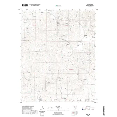
2020 Map of Pyatt
USGS Topo · Published 2020About this map
Dodd City and the surrounding high country of Marion County are defined by a dense network of named hollows and springs that flow toward Crooked Creek and the White River watershed. The landscape is marked by historical land use patterns, evidenced by family-named landmarks and secluded burials such as Derryberry Cem and Keesee Cem. In the northern reaches, names like Mining House Hollow and Lead Mine Cr suggest the area's mineral prospects, while the southern border centers on the community of Pyatt along the valley floor. The distribution of small settlements like Lakeway and Snow connected by winding roads like Hillbilly Hollow Rd reflects a traditional Ozark settlement pattern where life was organized around the topography of ridges like Linton Ridge and the constant water sources of Marble Falls Spring or Coon Spring.
Find a feature on this map
122 named features on this map. Tap any name to fly to it.
Don’t see what you’re looking for? This feature index may not catch every label — zoom into the map to look around manually.
Map Details
Editions of this 2020 Pyatt Map
This is the sole edition of this map. No revisions or reprints were ever made.
Other maps of this area

1893 · Yellville
USGS Topo · 1:125,000

1903 · Yellville
USGS Topo · 1:125,000

1905 · Yellville
USGS Topo · 1:125,000

1929 · Yellville
USGS Topo · 1:125,000

1945 · Harrison
USGS Topo · 1:250,000

1949 · Harrison
USGS Topo · 1:250,000

1954 · Harrison
USGS Topo · 1:250,000

1958 · Harrison
USGS Topo · 1:250,000

1964 · Harrison
USGS Topo · 1:250,000
1966 · Yellville
USGS Topo · 1:24,000