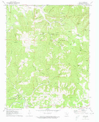
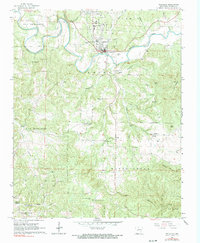
1972 Map of Pyatt
USGS Topo · Published 1973About this map
Pyatt and the winding Crooked Creek define the southern landscape of this Marion County region during the early 1970s. The area is characterized by a dense network of hollows and ridges, such as Welcome Ridge and Mining House Hollow, which reflect a history of small-scale mining and upland farming. Evidence of the local extractive industry is scattered across the terrain, including the Copperhead Mine, Markle Mine, and Bear Hill Mine.
Find a feature on this map
70 named features on this map. Tap any name to fly to it.
Don’t see what you’re looking for? This feature index may not catch every label — zoom into the map to look around manually.
Map Details
Editions of this 1972 Pyatt Map
This is the sole edition of this map. No revisions or reprints were ever made.
Other maps of this area

1893 · Yellville
USGS Topo · 1:125,000

1903 · Yellville
USGS Topo · 1:125,000

1905 · Yellville
USGS Topo · 1:125,000

1929 · Yellville
USGS Topo · 1:125,000

1945 · Harrison
USGS Topo · 1:250,000

1949 · Harrison
USGS Topo · 1:250,000

1954 · Harrison
USGS Topo · 1:250,000

1958 · Harrison
USGS Topo · 1:250,000

1964 · Harrison
USGS Topo · 1:250,000
1966 · Yellville
USGS Topo · 1:24,000