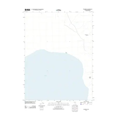
2011 Map of Pyramid NE
USGS Topo · Published 2011About this map
Pyramid Lake dominates this Nevada landscape, where the high desert meets the water at the northeast edge of the terminal basin. Along the shoreline, Fox Beach and the protected waters of Fox Bay mark the transition from the expansive lake to the rugged inland topography. The terrain rising from the water is defined by deep drainages and canyons that have shaped the region's accessibility. High above the eastern shore, the map details the descent of Sweetwater Canyon and the evocatively named Hells Kitchen Canyon, illustrating the steep vertical relief and drainage patterns typical of the Great Basin's endorheic systems.
Find a feature on this map
5 named features on this map. Tap any name to fly to it.
Don’t see what you’re looking for? This feature index may not catch every label — zoom into the map to look around manually.
Map Details
Editions of this 2011 Pyramid NE Map
This is the sole edition of this map. No revisions or reprints were ever made.
Other maps of this area

1886 · Granite Range
USGS Topo · 1:250,000

1894 · Granite Range
USGS Topo · 1:250,000

1955 · Lovelock
USGS Topo · 1:250,000

1959 · Lovelock
USGS Topo · 1:250,000

1964 · The Needle Rocks
USGS Topo · 1:24,000
1964 · Dove Creek
USGS Topo · 1:24,000

1964 · Tohakum Peak NW
USGS Topo · 1:24,000
1964 · Pyramid SW
USGS Topo · 1:24,000

1964 · Kumiva Peak
USGS Topo · 1:62,500

1964 · Pyramid NE
USGS Topo · 1:24,000