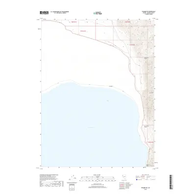
2018 Map of Pyramid NE
USGS Topo · Published 2018About this map
Pyramid Lake dominates the western half of this Nevada landscape, where the waters of Fox Bay meet the shoreline at Fox Beach. The topography is defined by the steep western face of the Lake Range, which rises sharply from the lake's edge. This dramatic elevation gain is carved by numerous drainages, including the prominent Sweetwater Canyon to the north and the descriptively named Hells Kitchen Canyon further south. Near the southern boundary of the quadrangle, the terrain becomes even more precipitous at Howitzer Slide. The lack of developed roads or settlements in this 2018 survey highlights the enduring isolation of this high desert environment, where the land is primarily partitioned by township lines such as t27n r22e and t28n r22e within Washoe County.
Find a feature on this map
12 named features on this map. Tap any name to fly to it.
Don’t see what you’re looking for? This feature index may not catch every label — zoom into the map to look around manually.
Map Details
Editions of this 2018 Pyramid NE Map
This is the sole edition of this map. No revisions or reprints were ever made.
Other maps of this area

1886 · Granite Range
USGS Topo · 1:250,000

1894 · Granite Range
USGS Topo · 1:250,000

1955 · Lovelock
USGS Topo · 1:250,000

1959 · Lovelock
USGS Topo · 1:250,000

1964 · The Needle Rocks
USGS Topo · 1:24,000
1964 · Dove Creek
USGS Topo · 1:24,000

1964 · Tohakum Peak NW
USGS Topo · 1:24,000
1964 · Pyramid SW
USGS Topo · 1:24,000

1964 · Kumiva Peak
USGS Topo · 1:62,500

1964 · Pyramid NE
USGS Topo · 1:24,000