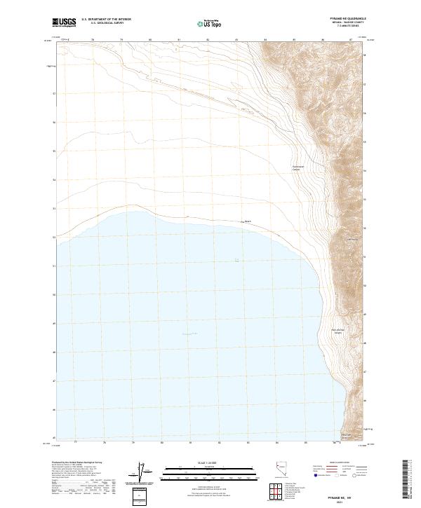
2021 Map of Pyramid NE
USGS Topo · Published 2021About this map
Pyramid Lake dominates the western portion of this landscape, its waters meeting the shoreline at Fox Bay and the stretches of Fox Beach. The eastern terrain rises sharply into the Lake Range, where the topography is defined by narrow drainage systems like Sweetwater Canyon and Hells Kitchen Canyon. These steep slopes terminate at features like Howitzer Slide, illustrating the dramatic vertical relief between the lake's edge and the high ridges. This map provides a detailed view of the natural boundary between the high desert waters and the arid peaks of Washoe County. The absence of modern infrastructure highlights the preserved, primitive character of this shoreline, where survey lines and township boundaries like t27n r22e provide the only human-imposed structure over the physical geography.
Find a feature on this map
12 named features on this map. Tap any name to fly to it.
Don’t see what you’re looking for? This feature index may not catch every label — zoom into the map to look around manually.
Map Details
Editions of this 2021 Pyramid NE Map
This is the sole edition of this map. No revisions or reprints were ever made.
Other maps of this area

1886 · Granite Range
USGS Topo · 1:250,000

1894 · Granite Range
USGS Topo · 1:250,000

1955 · Lovelock
USGS Topo · 1:250,000

1959 · Lovelock
USGS Topo · 1:250,000

1964 · The Needle Rocks
USGS Topo · 1:24,000
1964 · Dove Creek
USGS Topo · 1:24,000

1964 · Tohakum Peak NW
USGS Topo · 1:24,000
1964 · Pyramid SW
USGS Topo · 1:24,000

1964 · Kumiva Peak
USGS Topo · 1:62,500

1964 · Pyramid NE
USGS Topo · 1:24,000