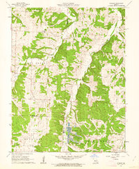
1961 Map of Pyrmont
USGS Topo · Published 1962About this map
The rural borderlands where Pettis, Benton, and Morgan Counties converge are defined by a complex network of timbered ridges and stream valleys in this early 1960s survey. The small settlement of Pyrmont serves as a local landmark in the southeastern corner, near where Gabriel Cr and Haw Creek flow through the landscape. For genealogists and local historians, the map is particularly useful for locating several family and community landmarks, including St Paul Cem, Lamb Cem, and the Lake Creek Ch and its associated cemetery. A notable modern addition to the landscape is the Fish Hatchery located in the center-south, south of where Lake Creek winds through the township of the same name. The area’s geography is shaped by numerous tributaries such as Little Haw Creek and McGee Branch, reflecting a mid-century period of established rural life and specialized agriculture before significant modern development altered these county boundaries.
Find a feature on this map
21 named features on this map. Tap any name to fly to it.
Don’t see what you’re looking for? This feature index may not catch every label — zoom into the map to look around manually.
Map Details
Editions of this 1961 Pyrmont Map
This is the sole edition of this map. No revisions or reprints were ever made.
Other maps of this area

1887 · Sedalia
USGS Topo · 1:125,000

1887 · Warsaw
USGS Topo · 1:125,000

1888 · Versailles
USGS Topo · 1:125,000

1888 · Boonville
USGS Topo · 1:125,000

1893 · Versailles
USGS Topo · 1:125,000

1894 · Warsaw
USGS Topo · 1:125,000

1894 · Sedalia
USGS Topo · 1:125,000

1904 · Gravois Mills
USGS Topo · 1:62,500

1944 · Sedalia East
USGS Topo · 1:24,000

1946 · Sedalia East
USGS Topo · 1:24,000