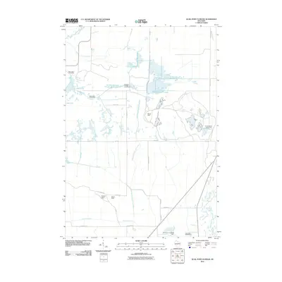
2010 Map of Quail Point Flowage
USGS Topo · Published 2010About this map
North Bluff and South Bluff rise above a complex landscape of wetlands and managed waterways in Wood County. This region is defined by its sophisticated hydraulic engineering, where the Gallagher Flowage Controls Dam and Corner Marsh Control Dam regulate the flow of the and West Gallagher Flowages 16 South-North and the South Gallagher Flowage. The drainage patterns are further defined by the Remington Ditch, which cuts across the terrain to manage water levels between the East Branch Little Yellow River and the Yellow River. In the southern portion of the quadrangle, the South Bluff Lookout Tower serves as a prominent landmark overlooking the marshes and forests. The map details an area primarily utilized for water management and wildlife habitat, connected by a network of local roads such as Ball Rd and Dairy Rd.
Find a feature on this map
32 named features on this map. Tap any name to fly to it.
Don’t see what you’re looking for? This feature index may not catch every label — zoom into the map to look around manually.
Map Details
Editions of this 2010 Quail Point Flowage Map
This is the sole edition of this map. No revisions or reprints were ever made.
Other maps of this area

1953 · Eau Claire
USGS Topo · 1:250,000

1957 · Pittsville
USGS Topo · 1:48,000

1957 · City Point
USGS Topo · 1:48,000

1958 · Eau Claire
USGS Topo · 1:250,000

1958 · Necedah
USGS Topo · 1:48,000

1958 · Wyeville
USGS Topo · 1:48,000

1964 · Eau Claire
USGS Topo · 1:250,000

1967 · Pittsville
USGS Topo · 1:62,500
1969 · New Miner
USGS Topo · 1:24,000
1969 · Finley
USGS Topo · 1:24,000