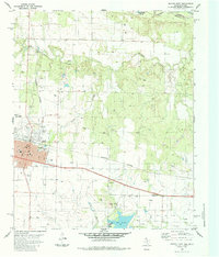
1984 Map of Quanah East
USGS Topo · Published 1985About this map
The railroad town of Quanah serves as the focal point of this Hardeman County landscape, where the Burlington Northern line cuts through the prairie toward the Oklahoma Texas border. Industrial development is evident throughout the terrain, from the Conley Oil Field and numerous Oil Wells to the Power Plant situated along the shores of Lake Pauline. Local civic life is represented by the High Sch, Memorial Park (Cem), and a local Golf Course. To the north, the winding path of Groesbeck Creek and Spring Creek leads toward the Red River valley, marking the transition from town lots to the wider ranching and oil-producing territory. This survey documents a mid-1980s period of intersection between the established town grid and the active energy and agricultural sectors of North Texas.
Find a feature on this map
38 named features on this map. Tap any name to fly to it.
Don’t see what you’re looking for? This feature index may not catch every label — zoom into the map to look around manually.
Map Details
Editions of this 1984 Quanah East Map
This is the sole edition of this map. No revisions or reprints were ever made.
Other maps of this area

1927 · Quanah 3-a
USGS Topo · 1:48,000

1932 · Vivian
USGS Topo · 1:62,500

1955 · Lawton
USGS Topo · 1:250,000

1958 · Medicine Mound
USGS Topo · 1:62,500

1960 · Goodlett
USGS Topo · 1:62,500

1960 · Teacup Mountain
USGS Topo · 1:62,500

1960 · Quanah
USGS Topo · 1:62,500

1975 · Quanah NE
USGS Topo · 1:24,000

1975 · Quanah NW
USGS Topo · 1:24,000

1983 · Big Mound
USGS Topo · 1:24,000