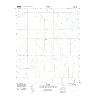
2012 Map of Quanah NE
USGS Topo · Published 2012About this map
The Red River corridor defines the southern portion of this landscape, carving a wide path through the Oklahoma-Texas borderlands. North of the river, a rigid section-line road network organizes the agricultural terrain, featuring local routes such as Taylor Rd and Huneycutt Rd. In the central portion of the map, the Odema Cem stands as a quiet marker of the area's rural community history. The hydrology is dominated by intermittent drainage patterns, with Mule Cr and Sandy Cr feeding into the main river channel. This 2012 survey illustrates the persistence of family-named landmarks in Jackson County, where routes like King's High Rd and Mulkey Rd continue to serve as primary arteries for the region's ranching and farming operations.
Find a feature on this map
25 named features on this map. Tap any name to fly to it.
Don’t see what you’re looking for? This feature index may not catch every label — zoom into the map to look around manually.
Map Details
Editions of this 2012 Quanah NE Map
This is the sole edition of this map. No revisions or reprints were ever made.
Other maps of this area

1955 · Lawton
USGS Topo · 1:250,000

1958 · Elmer
USGS Topo · 1:62,500

1960 · Quanah
USGS Topo · 1:62,500

1964 · Olustee
USGS Topo · 1:24,000

1971 · Duke SW
USGS Topo · 1:24,000

1971 · Prairie Hill
USGS Topo · 1:24,000

1975 · Quanah NE
USGS Topo · 1:24,000

1975 · Quanah NW
USGS Topo · 1:24,000
1984 · Quanah NE
USGS Topo · 1:24,000
1984 · Quanah East
USGS Topo · 1:24,000