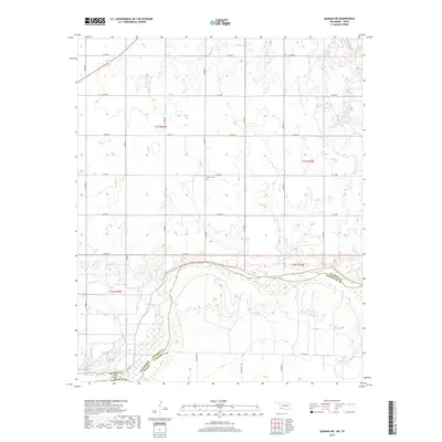
2019 Map of Quanah NE
USGS Topo · Published 2019About this map
The Red River defines the southern boundary of this landscape, separating Jackson County, Oklahoma, from Hardeman County, Texas. This borderland region is characterized by a systematic grid of agricultural section lines, including N1900 Rd and E1770 Rd, which navigate the terrain around significant watercourses like Mule Cr and Sandy Cr. These drainage patterns are vital to the local geography, feeding into the main river channel which shifts through sandy banks and wetlands. For those tracing local history or family roots in the area, the Odema Cem stands as a central landmark amidst the fields, located north of the river near the intersection of several section roads. The map captures the enduring rural character of this Red River crossing point, where the landscape is still defined by its traditional township and range divisions.
Find a feature on this map
28 named features on this map. Tap any name to fly to it.
Don’t see what you’re looking for? This feature index may not catch every label — zoom into the map to look around manually.
Map Details
Editions of this 2019 Quanah NE Map
This is the sole edition of this map. No revisions or reprints were ever made.
Other maps of this area

1955 · Lawton
USGS Topo · 1:250,000

1958 · Elmer
USGS Topo · 1:62,500

1960 · Quanah
USGS Topo · 1:62,500

1964 · Olustee
USGS Topo · 1:24,000

1971 · Duke SW
USGS Topo · 1:24,000

1971 · Prairie Hill
USGS Topo · 1:24,000

1975 · Quanah NE
USGS Topo · 1:24,000

1975 · Quanah NW
USGS Topo · 1:24,000
1984 · Quanah NE
USGS Topo · 1:24,000
1984 · Quanah East
USGS Topo · 1:24,000