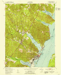
1952 Map of Quantico
USGS Topo · Published 1953About this map
The Quantico Marine Base dominates this Potomac River shoreline, illustrating the mid-century expansion of military infrastructure alongside established coastal communities. The landscape is defined by the strategic intersection of the Jefferson Davis Highway and the Richmond Fredericksburg and Potomac railroad, which together anchor the settlements of Triangle and Dumfries. Near the water, specialized facilities like the US Naval Hospital and the Marine Corps Air Station sit adjacent to Chopawamsic Creek.
Find a feature on this map
27 named features on this map. Tap any name to fly to it.
Don’t see what you’re looking for? This feature index may not catch every label — zoom into the map to look around manually.
Map Details
Editions of this 1952 Quantico Map
This is the sole edition of this map. No revisions or reprints were ever made.
Other maps of this area

1889 · Fredericksburg
USGS Topo · 1:125,000

1890 · Mt. Vernon
USGS Topo · 1:125,000

1891 · Mt. Vernon
USGS Topo · 1:125,000

1892 · Fredericksburg
USGS Topo · 1:125,000

1894 · Fredericksburg
USGS Topo · 1:125,000

1894 · Mt. Vernon
USGS Topo · 1:125,000

1897 · Mt. Vernon
USGS Topo · 1:125,000

1913 · Indian Head
USGS Topo · 1:62,500

1913 · Nanjemoy
USGS Topo · 1:62,500

1923 · Indian Head
USGS Topo · 1:48,000