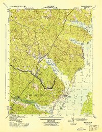
1944 Map of Quantico
USGS Topo · Published 1944About this map
The Marine Corps Reservation dominates the southern landscape of this coastal Virginia region during the second World War. The critical corridor between Washington and Richmond is defined by the Jefferson Davis Highway and the Richmond Fredericksburg and Potomac railroad, which serve as the primary arteries for movement through Triangle and the established town of Dumfries. Along the Potomac River, specialized land use is evident at the Fish Hatchery and numerous points such as Possum Pt and Cockpit Pt.
Find a feature on this map
31 named features on this map. Tap any name to fly to it.
Don’t see what you’re looking for? This feature index may not catch every label — zoom into the map to look around manually.
Map Details
Editions of this 1944 Quantico Map
2 editions found
Other maps of this area

1889 · Fredericksburg
USGS Topo · 1:125,000

1890 · Mt. Vernon
USGS Topo · 1:125,000

1891 · Mt. Vernon
USGS Topo · 1:125,000

1892 · Fredericksburg
USGS Topo · 1:125,000

1894 · Fredericksburg
USGS Topo · 1:125,000

1894 · Mt. Vernon
USGS Topo · 1:125,000

1897 · Mt. Vernon
USGS Topo · 1:125,000

1913 · Indian Head
USGS Topo · 1:62,500

1913 · Nanjemoy
USGS Topo · 1:62,500

1923 · Indian Head
USGS Topo · 1:48,000