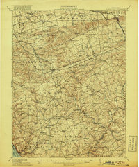
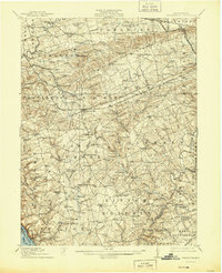
1912 Map of Quarryville
USGS Topo · Published 1918About this map
Quarryville and Strasburg serve as the primary hubs in this early twentieth-century survey of southern Lancaster County, where the landscape is defined by a dense network of township roads and several distinct rail lines. The Pennsylvania RR and its Susquehanna Valley Branch cut through the central hills, while the Peach Bottom RR and Oxford and Southern RR serve the southern farming communities. Local industry is anchored by the Nickel Mines and the nearby Nickel Mines Run, while rural life centers on an exceptionally high concentration of small schoolhouses such as Winter Hill School, North Star School, and Mars Hill School.
Find a feature on this map
123 named features on this map. Tap any name to fly to it.
Don’t see what you’re looking for? This feature index may not catch every label — zoom into the map to look around manually.
Map Details
Editions of this 1912 Quarryville Map
6 editions found

Other maps of this area

1898 · Elkton
USGS Topo · 1:62,500

1900 · Elkton
USGS Topo · 1:62,500

1900 · Havre De Grace
USGS Topo · 1:62,500

1901 · Belair
USGS Topo · 1:62,500

1902 · Lancaster
USGS Topo · 1:62,500

1904 · Lancaster
USGS Topo · 1:62,500

1904 · Coatesville
USGS Topo · 1:62,500

1905 · Honey Brook
USGS Topo · 1:62,500

1906 · Coatesville
USGS Topo · 1:62,500

1906 · New Holland
USGS Topo · 1:62,500
Featured Places
- West Lampeter Township, PA
- Willow Street, West Lampeter Township
- Paradise Township, PA
- Little Britain Township, PA
- Quarryville, PA