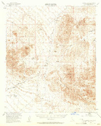
1953 Map of Quartz Peak
USGS Topo · Published 1961About this map
The Chocolate Mountains and Black Mountains dominate this 1953 landscape, a period when the California desert was a landscape of active extraction and military reservation. Mining operations are scattered throughout the peaks, including the Paymaster Mine in the north and the Rainbow Mine further south. The presence of the Aerial Gunnery Range and Naval Res Bdy underscores the region's transition to defense use during the mid-century. Vital water sources for prospectors and travelers are clearly marked in this arid environment, from the Peter Kane Water Hole to Arrowweed Springs & Well. Local aviation infrastructure is represented by a remote Landing Strip near Imperial Gables, providing a glimpse into the logistical challenges of the era. Other notable landmarks include Quartz Peak and the Old Channel Mine Shaft, reflecting the deep history of mineral exploration in Imperial County.
Find a feature on this map
28 named features on this map. Tap any name to fly to it.
Don’t see what you’re looking for? This feature index may not catch every label — zoom into the map to look around manually.
Map Details
Editions of this 1953 Quartz Peak Map
4 editions found

Other maps of this area

1903 · Yuma
USGS Topo · 1:125,000

1905 · Yuma
USGS Topo · 1:125,000

1907 · Holtville
USGS Topo · 1:125,000

1942 · El Centro
USGS Topo · 1:250,000

1942 · Yuma
USGS Topo · 1:250,000

1942 · Blythe
USGS Topo · 1:250,000

1945 · Picacho Peak
USGS Topo · 1:62,500

1945 · Cibola
USGS Topo · 1:62,500

1945 · Picacho
USGS Topo · 1:62,500

1951 · Picacho
USGS Topo · 1:62,500