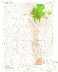
1952 Map of Quartzite Mtn
USGS Topo · Published 1964About this map
The Las Vegas Bombing and Gunnery Range dominates this mid-century landscape in Nye County, showing a transition from early pioneer mining to Cold War military operations. The rugged Kawich Range rises sharply between the desert expanses of Gold Flat and Kawich Valley, sheltering the old mining district of the Gold Reed (Site). Evidence of prospectors and ranchers remains in the form of a designated Mining Area and the Wild Horse Ranch, alongside survival-critical water points like Cedar Wells and the Jackpot Reservoir. Several labeled Target areas and an Abandoned Landing Strip underscore the area's repurposing for aerial training. The presence of Quartzite Mtn and Cedar Pass highlights the natural corridors and obstacles that dictated travel through this arid high-desert terrain.
Find a feature on this map
19 named features on this map. Tap any name to fly to it.
Don’t see what you’re looking for? This feature index may not catch every label — zoom into the map to look around manually.
Map Details
Editions of this 1952 Quartzite Mtn Map
4 editions found
Other maps of this area

1908 · Kawich
USGS Topo · 1:250,000

1942 · Tolicha Peak
USGS Topo · 1:125,000

1942 · Cactus Range
USGS Topo · 1:125,000

1942 · Reveille Peak
USGS Topo · 1:125,000

1942 · Wheelbarrow Peak
USGS Topo · 1:125,000

1952 · Stinking Spring
USGS Topo · 1:62,500

1952 · Mellan
USGS Topo · 1:62,500

1952 · Kawich Peak
USGS Topo · 1:62,500

1952 · Quartzite Mtn
USGS Topo · 1:62,500

1952 · Reveille Peak
USGS Topo · 1:62,500