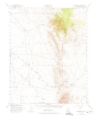
1952 Map of Quartzite Mtn
USGS Topo · Published 1975About this map
The Las Vegas Bombing and Gunnery Range dominates this mid-century topographic study, designating much of the desert floor as restricted territory. Military infrastructure is scattered across the dry terrain, including several targets and towers utilized for training. This era of activity is superimposed over an earlier mineral-driven history, evidenced by the mining area near Gold Reed Pass and the Gold Reed (Site) itself.
Find a feature on this map
24 named features on this map. Tap any name to fly to it.
Don’t see what you’re looking for? This feature index may not catch every label — zoom into the map to look around manually.
Map Details
Editions of this 1952 Quartzite Mtn Map
4 editions found
Other maps of this area

1908 · Kawich
USGS Topo · 1:250,000

1942 · Tolicha Peak
USGS Topo · 1:125,000

1942 · Cactus Range
USGS Topo · 1:125,000

1942 · Reveille Peak
USGS Topo · 1:125,000

1942 · Wheelbarrow Peak
USGS Topo · 1:125,000

1952 · Stinking Spring
USGS Topo · 1:62,500

1952 · Mellan
USGS Topo · 1:62,500

1952 · Kawich Peak
USGS Topo · 1:62,500

1952 · Quartzite Mtn
USGS Topo · 1:62,500

1952 · Reveille Peak
USGS Topo · 1:62,500