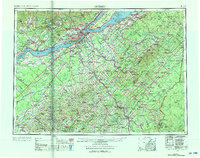
1962 Map of Quebec
USGS Topo · Published 1976About this map
St. Lawrence River dominates the landscape as it flows between the metropolitan centers of Quebec, Levis, and Lauzon. This 1962 road and rail data shows a region defined by its industrial transit and river access, where the Canadian National Railway and Canadian Pacific Railway meet at major junctions. To the north, the Valcartier Military Reserve borders the rising Laurentian Mountains, while to the south, the terrain transitions into the Appalachian Mountains. The map details the extraction economies of the era, notably at Thetford Mines and Black Lake, alongside well-established parishes like Ste-Foy and Giffard. Large river features like Ile d'Orleans and Ile aux Grues highlight the historic maritime settlements and navigation points crucial to the province's development during the mid-20th century.
Find a feature on this map
274 named features on this map. Tap any name to fly to it.
Don’t see what you’re looking for? This feature index may not catch every label — zoom into the map to look around manually.
Map Details
Editions of this 1962 Quebec Map
3 editions found

Other maps of this area

1927 · Sandy Bay
USGS Topo · 1:48,000

1930 · Sandy Bay
USGS Topo · 1:62,500

1944 · Sandy Bay
USGS Topo · 1:62,500

1949 · Jackman
USGS Topo · 1:250,000

1954 · Seboomook Lake
USGS Topo · 1:62,500

1954 · Baker Lake
USGS Topo · 1:62,500

1954 · St. John Pond
USGS Topo · 1:62,500

1954 · Presque Isle
USGS Topo · 1:250,000

1954 · Millinocket
USGS Topo · 1:250,000

1955 · Depot Lake
USGS Topo · 1:62,500