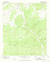
1965 Map of Queens Head
USGS Topo · Published 1968About this map
The Apache National Forest and Gila National Forest converge in this mid-1960s survey of high-elevation terrain in Catron County. The landscape is defined by its complex network of seasonal water management and natural springs, vital for the region's ranching and forestry operations. Named landmarks like Queens Head and Negrohead Butte rise above a series of deep drainages including Hardcastle Canyon and Bear Canyon. Human presence is marked by isolated outposts such as the Jewett Work Center and specialized improvements like East Camp Windmill and Gann Windmill. The map captures a high-country environment where water is the primary driver of development, evidenced by the numerous tanks and springs like Fitzgerald Cienega, Lower Water Spring, and Yankee Spring. This document provides an essential record of mid-century land use in the New Mexico wilderness, documenting the placement of livestock tanks and forest service infrastructure across the continental divide region.
Find a feature on this map
87 named features on this map. Tap any name to fly to it.
Don’t see what you’re looking for? This feature index may not catch every label — zoom into the map to look around manually.
Map Details
Editions of this 1965 Queens Head Map
2 editions found
Other maps of this area

1915 · Reserve
USGS Topo · 1:125,000

1918 · Reserve
USGS Topo · 1:125,000

1954 · Clifton
USGS Topo · 1:250,000

1954 · Saint Johns
USGS Topo · 1:250,000

1957 · Clifton
USGS Topo · 1:250,000

1957 · Saint Johns
USGS Topo · 1:250,000

1958 · Clifton
USGS Topo · 1:250,000

1958 · Saint Johns
USGS Topo · 1:250,000

1962 · Clifton
USGS Topo · 1:250,000

1962 · Saint Johns
USGS Topo · 1:250,000