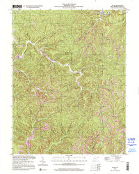
2000 Map of Quick
USGS Topo · Published 2001About this map
Blue Creek and its many winding tributaries define the settlement patterns of this Kanawha County landscape as documented by the U.S. Geological Survey at the close of the twentieth century. Small residential clusters and rural outposts such as Quick, Coalridge, and Blount are situated within the deep valleys of the Elk, Malden, and Cabin Creek districts. The map reveals a community infrastructure built around local education and faith, featuring the Pointlick Sch, Hansford Sch, and Tenmile Sch, alongside Grace Ch. Industrial activity is marked by the Book Mine and a secondary Mine, while a complex network of Pipelines traverses the terrain between Fivemile and Putney. To the south, larger settlements like Witcher, Mammoth, and Ward anchor the map near the Counterfeit Branch and Witcher Creek drainages.
Find a feature on this map
48 named features on this map. Tap any name to fly to it.
Don’t see what you’re looking for? This feature index may not catch every label — zoom into the map to look around manually.
Map Details
Editions of this 2000 Quick Map
This is the sole edition of this map. No revisions or reprints were ever made.
Other maps of this area

1897 · Kanawha Falls
USGS Topo · 1:125,000

1899 · Charleston
USGS Topo · 1:125,000

1900 · Kanawha Falls
USGS Topo · 1:125,000

1901 · Kanawha Falls
USGS Topo · 1:125,000

1907 · Clendenin
USGS Topo · 1:62,500

1908 · Montgomery
USGS Topo · 1:48,000

1909 · Charleston
USGS Topo · 1:62,500

1909 · Clendenin
USGS Topo · 1:62,500

1909 · Peytona
USGS Topo · 1:48,000

1910 · Montgomery
USGS Topo · 1:62,500