
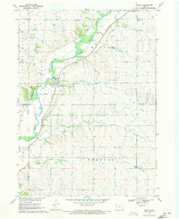
1969 Map of Quimby SE
USGS Topo · Published 1971About this map
The western edge of Holstein and the agricultural landscape of Griggs township dominate this 1969 survey of the rural Ida and Cherokee County line. The terrain is defined by the drainage patterns of Silver Creek, Fourmile Creek, and Ashton Creek, which carve through the high ground of the Iowa prairies. This specific map records the interface between the growing town of Holstein and the surrounding farm sections during the late 1960s, a period of modernized agriculture following the development of the Missouri River Basin. Genealogists and local historians will find the exact locations of the Silver Cem and Holstein Cem, along with the distinctive Radio Tower landmark that punctuated the rural skyline. The map's detailed section lines and property boundaries provide a clear view of the land division across the townships of Willow, Diamond, and Silver.
Find a feature on this map
14 named features on this map. Tap any name to fly to it.
Don’t see what you’re looking for? This feature index may not catch every label — zoom into the map to look around manually.
Map Details
Editions of this 1969 Quimby SE Map
This is the sole edition of this map. No revisions or reprints were ever made.
Other maps of this area

1954 · Fort Dodge
USGS Topo · 1:250,000

1957 · Fort Dodge
USGS Topo · 1:250,000

1958 · Fort Dodge
USGS Topo · 1:250,000

1967 · Holstein
USGS Topo · 1:24,000

1967 · Ida Grove NW
USGS Topo · 1:24,000

1969 · Aurelia
USGS Topo · 1:24,000

1969 · Cherokee South
USGS Topo · 1:24,000

1969 · Galva
USGS Topo · 1:24,000

1969 · Cushing
USGS Topo · 1:24,000
1969 · Washta
USGS Topo · 1:24,000