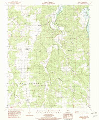
1982 Map of Quincy
USGS Topo · Published 1982About this map
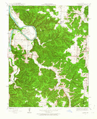
Quincy and Bentonville serve as central points in this Ozark borderland during the early 1980s, where the landscape is defined by the winding course of the Pomme de Terre River. The transition from the Alexander and Montgomery townships into the newly established waters of the Harry S Truman Reservoir highlights a period of significant geographical change for this corner of Hickory and Benton Counties.
Find a feature on this map
38 named features on this map. Tap any name to fly to it.
Don’t see what you’re looking for? This feature index may not catch every label — zoom into the map to look around manually.
Map Details
Editions of this 1982 Quincy Map
This is the sole edition of this map. No revisions or reprints were ever made.
Other maps of this area

1884 · Bolivar
USGS Topo · 1:125,000

1886 · Stockton
USGS Topo · 1:125,000

1887 · Clinton
USGS Topo · 1:125,000

1887 · Warsaw
USGS Topo · 1:125,000

1892 · Bolivar
USGS Topo · 1:125,000

1894 · Warsaw
USGS Topo · 1:125,000

1894 · Clinton
USGS Topo · 1:125,000

1935 · Dell
USGS Topo · 1:24,000

1940 · Weaubleau
USGS Topo · 1:24,000
1940 · Iconium
USGS Topo · 1:24,000