
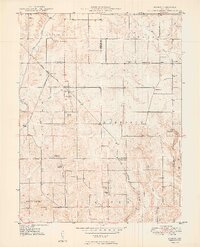
1949 Map of Quincy
USGS Topo · Published 1949About this map
Quincy stands at a pivotal rail junction in northwestern Owen County, where the Chicago Indianapolis And Louisville railroad snakes through the undulating terrain. This late-1940s landscape is defined by its rural social centers, featuring a high density of country churches and family-named cemeteries that reflect generations of settlement along the county lines of Putnam, Morgan, and Owen. Notable congregations include Smyrna Ch, Amity Ch, and Montgomery Chapel, while local education is anchored by landmarks like School No. 3.
Find a feature on this map
36 named features on this map. Tap any name to fly to it.
Don’t see what you’re looking for? This feature index may not catch every label — zoom into the map to look around manually.
Map Details
Editions of this 1949 Quincy Map
2 editions found
Other maps of this area

1947 · Gosport
USGS Topo · 1:24,000

1950 · Gosport
USGS Topo · 1:24,000

1953 · Indianapolis
USGS Topo · 1:250,000

1955 · Hall
USGS Topo · 1:24,000

1956 · Indianapolis
USGS Topo · 1:250,000

1956 · Cloverdale
USGS Topo · 1:24,000

1956 · Cataract
USGS Topo · 1:24,000

1956 · Eminence
USGS Topo · 1:24,000
1956 · Spencer
USGS Topo · 1:24,000

1957 · Indianapolis
USGS Topo · 1:250,000