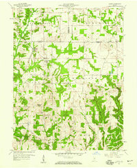
1958 Map of Quincy
USGS Topo · Published 1959About this map
Quincy serves as the central hub of this mid-century topographic record, where the Monon railroad corridor cuts through the landscape to meet Wallace Junction. The map illustrates a transitional rural geography across the Owen, Putnam, and Morgan county lines, defined by a network of local congregations and burial grounds like Hudson Hill Ch and Little Mount Cem. A significant historical landmark is the Treaty Boundary running diagonally through the southern sections, marking a line of earlier land cession. The terrain is deeply etched by waterways such as Mill Creek and Monon Creek, supporting a scattered settlement pattern that includes the small hamlets of Alaska and Lewisville. An isolated Quarry near the eastern edge suggests localized industrial activity amidst the predominantly agricultural and wooded hills of the late 1950s.
Find a feature on this map
35 named features on this map. Tap any name to fly to it.
Don’t see what you’re looking for? This feature index may not catch every label — zoom into the map to look around manually.
Map Details
Editions of this 1958 Quincy Map
2 editions found

Other maps of this area

1947 · Gosport
USGS Topo · 1:24,000

1949 · Quincy
USGS Topo · 1:24,000

1950 · Gosport
USGS Topo · 1:24,000

1953 · Indianapolis
USGS Topo · 1:250,000

1955 · Hall
USGS Topo · 1:24,000

1956 · Indianapolis
USGS Topo · 1:250,000

1956 · Cloverdale
USGS Topo · 1:24,000

1956 · Cataract
USGS Topo · 1:24,000

1956 · Eminence
USGS Topo · 1:24,000
1956 · Spencer
USGS Topo · 1:24,000