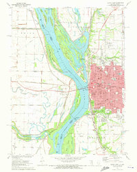
1971 Map of Quincy West
USGS Topo · Published 1973About this map
The city of Quincy dominates the eastern bluffs of the Mississippi River, serving as a dense urban center characterized by its numerous religious and educational institutions. The map reveals a high concentration of schools and parochial facilities, including the Illinois Soldiers and Sailors Home, Quincy College, and the Our Lady of Angels Seminary. Along the riverfront, industrial and civic infrastructure is evident through the Waterworks, various pumping stations, and the massive Lock and Dam No 21. Across the river in Missouri, the landscape shifts dramatically to a network of levees and winding waterways like the Fabius River and Cottonwood Chute. This contrast highlights the mid-century development of the Illinois riverbank against the managed agricultural floodplains of the west. Notable public spaces like Indian Mounds Park and the Mark Twain Wildlife Refuge frame the river, reflecting the area's dual identity as both a regional hub and a significant riparian corridor.
Find a feature on this map
92 named features on this map. Tap any name to fly to it.
Don’t see what you’re looking for? This feature index may not catch every label — zoom into the map to look around manually.
Map Details
Editions of this 1971 Quincy West Map
This is the sole edition of this map. No revisions or reprints were ever made.
Other maps of this area

1903 · Kahoka
USGS Topo · 1:125,000

1903 · Palmyra
USGS Topo · 1:125,000

1925 · Quincy
USGS Topo · 1:62,500

1944 · Quincy
USGS Topo · 1:62,500

1945 · Quincy
USGS Topo · 1:62,500

1946 · Mendon
USGS Topo · 1:62,500

1948 · Quincy
USGS Topo · 1:250,000

1948 · Mendon
USGS Topo · 1:62,500

1949 · Maywood
USGS Topo · 1:24,000

1949 · Palmyra
USGS Topo · 1:24,000