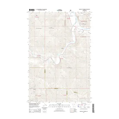
2014 Map of Quinns Hot Springs
USGS Topo · Published 2014About this map
Quinns Hot Springs sits at the heart of this terrain where the Clark Fork and Flathead River meet, carving through the high peaks of the Coeur d'Alene Mountains. The map documents a landscape defined by sharp elevation changes and narrow river corridors, bounded largely by the Lolo National Forest. The small settlement of Quinns and the rail-aligned community of Hopkins represent the primary human footprints in this wilderness, connected by the winding path of State Hwy 135. Notable landmarks like the John Tunnel and the waters of Bass Pond illustrate the engineering and natural features required to navigate this portion of Sanders County. Water is a dominant theme, from the roaring Cascade Falls to the numerous drainages like Fourteenmile Cr and Kennedy Cr that feed the primary river systems.
Find a feature on this map
45 named features on this map. Tap any name to fly to it.
Don’t see what you’re looking for? This feature index may not catch every label — zoom into the map to look around manually.
Map Details
Editions of this 2014 Quinns Hot Springs Map
This is the sole edition of this map. No revisions or reprints were ever made.
Other maps of this area

1956 · Wallace
USGS Topo · 1:250,000

1959 · Tarkio
USGS Topo · 1:62,500

1959 · Perma
USGS Topo · 1:62,500

1959 · Plains
USGS Topo · 1:62,500

1960 · Wallace
USGS Topo · 1:250,000

1960 · Superior
USGS Topo · 1:62,500

1983 · Horsehead Peak
USGS Topo · 1:24,000
1984 · Paradise
USGS Topo · 1:24,000
1984 · Sunrise Spring
USGS Topo · 1:24,000
1984 · Knowles
USGS Topo · 1:24,000