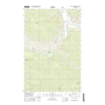
2017 Map of Quinns Hot Springs
USGS Topo · Published 2017About this map
Quinns Hot Springs serves as a central landmark where the Clark Fork river snakes through the steep elevations of the Coeur d'Alene Mountains. This 2017 survey by the U.S. Geological Survey captures the confluence area where the Flathead River joins the Clark Fork, a vital corridor for both transport and hydrology in Sanders County. The landscape is dominated by the protected timberlands of the Lolo National Forest, reaching high points at Patricks Knob and plunging into drainages like Hall Gulch and Much Water Cr. Local infrastructure is visible in the presence of John Tunnel and the small settlement of Quinns, reflecting the long-standing intersection of natural thermal features and the railroad-influenced geography of the river canyon. This modern edition provides a clear view of the complex terrain, from Cascade Falls to the various named creeks that define the regional watershed.
Find a feature on this map
35 named features on this map. Tap any name to fly to it.
Don’t see what you’re looking for? This feature index may not catch every label — zoom into the map to look around manually.
Map Details
Editions of this 2017 Quinns Hot Springs Map
This is the sole edition of this map. No revisions or reprints were ever made.
Other maps of this area

1956 · Wallace
USGS Topo · 1:250,000

1959 · Tarkio
USGS Topo · 1:62,500

1959 · Perma
USGS Topo · 1:62,500

1959 · Plains
USGS Topo · 1:62,500

1960 · Wallace
USGS Topo · 1:250,000

1960 · Superior
USGS Topo · 1:62,500

1983 · Horsehead Peak
USGS Topo · 1:24,000
1984 · Paradise
USGS Topo · 1:24,000
1984 · Sunrise Spring
USGS Topo · 1:24,000
1984 · Knowles
USGS Topo · 1:24,000