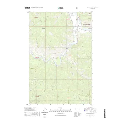
2020 Map of Quinns Hot Springs
USGS Topo · Published 2020About this map
Quinns Hot Springs sits at the heart of this mountain landscape, where the Clark Fork river carves a deep path through the Lolo National Forest. The map captures the complex topography of the Coeur d'Alene Mountains, including prominent peaks like Patricks Knob. A significant transport and utility corridor follows the river valley, evidenced by the John Tunnel and a network of mountain roads such as Pardee Creek Rd. The convergence of the Flathead River and the Clark Fork in the northern section highlights the area's role as a major regional drainage. Smaller water features like Much Water Cr, Cascade Falls, and the secluded Bass Pond drain the surrounding timberlands, while sites like Pardee Camp reflect the area's long-standing connection to forest management and recreation.
Find a feature on this map
42 named features on this map. Tap any name to fly to it.
Don’t see what you’re looking for? This feature index may not catch every label — zoom into the map to look around manually.
Map Details
Editions of this 2020 Quinns Hot Springs Map
This is the sole edition of this map. No revisions or reprints were ever made.
Other maps of this area

1956 · Wallace
USGS Topo · 1:250,000

1959 · Tarkio
USGS Topo · 1:62,500

1959 · Perma
USGS Topo · 1:62,500

1959 · Plains
USGS Topo · 1:62,500

1960 · Wallace
USGS Topo · 1:250,000

1960 · Superior
USGS Topo · 1:62,500

1983 · Horsehead Peak
USGS Topo · 1:24,000
1984 · Paradise
USGS Topo · 1:24,000
1984 · Sunrise Spring
USGS Topo · 1:24,000
1984 · Knowles
USGS Topo · 1:24,000