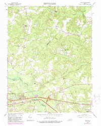
1965 Map of Quinton
USGS Topo · Published 1987About this map
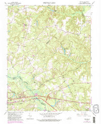
Chickahominy River and its extensive tributary networks of Cattail Swamp and Black Creek anchor this mid-century look at the borderlands of New Kent, Hanover, and Henrico counties. The landscape is defined by its water-driven history, with remnants of local industry visible at Parsleys Millpond and Flanagans Millpond. The emergence of modern transportation is evident where the interstate intersects the southern portion of the map near Bottoms Bridge, contrasting with the more traditional settlement patterns found at Quinton and Blacks Store. Several rural sanctuaries, including Hopewell Ch and Providence Ch, remain central to the community's layout. On the northwestern edge, an old railroad grade traces a former path through the timber, while newer residential developments like Woodhaven Shores reflect the era's changing land use.
Find a feature on this map
46 named features on this map. Tap any name to fly to it.
Don’t see what you’re looking for? This feature index may not catch every label — zoom into the map to look around manually.
Map Details
Editions of this 1965 Quinton Map
5 editions found
Other maps of this area

1894 · Bermuda Hundred
USGS Topo · 1:62,500

1894 · Richmond
USGS Topo · 1:62,500

1895 · Richmond
USGS Topo · 1:62,500

1918 · Charles City
USGS Topo · 1:62,500

1920 · King William
USGS Topo · 1:62,500

1934 · Seven Pines
USGS Topo · 1:24,000

1938 · Dutch Gap
USGS Topo · 1:24,000

1938 · Seven Pines
USGS Topo · 1:31,680

1938 · Studley
USGS Topo · 1:31,680

1943 · Dutch Gap
USGS Topo · 1:31,680