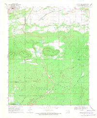
1969 Map of Quinton South
USGS Topo · Published 1971About this map
The northern slopes of the San Bois Mountains dominate this late-1960s landscape, where natural resource extraction and conservation exist side-by-side. Near the Haskell and Latimer county lines, the topography transitions from the high peaks of Tucker Knob and Panther Mountain down to the industrial activity surrounding Quinton and Lewisville. Evidence of the area's coal-mining history is visible through multiple Strip Mine and Mines labels, alongside an Old Railroad Grade that once served these operations. To the south, the terrain becomes more sequestered within the boundaries of Robbers Cave State Park. Here, the land is defined by water and recreation, featuring Lake Wayne Wallace, Rough Canyon, and Youth Camp No 2. This survey captures the region as it balanced its identity between a hard-working mining district and a growing destination for outdoor exploration.
Find a feature on this map
33 named features on this map. Tap any name to fly to it.
Don’t see what you’re looking for? This feature index may not catch every label — zoom into the map to look around manually.
Map Details
Editions of this 1969 Quinton South Map
4 editions found
Other maps of this area

1900 · Sansbois
USGS Topo · 1:125,000

1901 · Tuskahoma
USGS Topo · 1:125,000

1908 · Tuskahoma
USGS Topo · 1:125,000

1909 · Tuskahoma
USGS Topo · 1:125,000

1909 · Sans Bois
USGS Topo · 1:125,000

1911 · Sansbois
USGS Topo · 1:125,000

1940 · Red Oak
USGS Topo · 1:62,500

1943 · Red Oak
USGS Topo · 1:62,500

1946 · Fort Smith
USGS Topo · 1:250,000

1950 · Mcalester
USGS Topo · 1:250,000