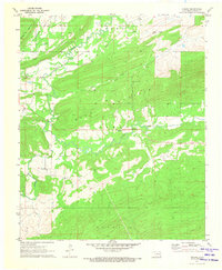
1971 Map of Higgins
USGS Topo · Published 1973About this map
Gaines Creek winds through the heart of this Latimer County landscape, where the flat valley floors meet the prominent ridges of Blue Mountain and Buffalo Mountain. At the time of this 1971 field check, the settlement of Higgins serves as a central point in an area defined by both its natural drainage and its industrial infrastructure. The transportation history of the region is clearly visible, with the Chicago Rock Island and Pacific railroad cutting through the terrain alongside an Old Railroad Grade that suggests earlier corridors of transit. Scattered industrial sites, including a Gravel Pit, Oil Well locations, and several Gas Wells, point to the extraction economy that shaped this part of Oklahoma. For genealogists and local historians, the Mountain Station Cem offers a specific point of interest situated along the northern slopes of the central ridge system.
Find a feature on this map
14 named features on this map. Tap any name to fly to it.
Don’t see what you’re looking for? This feature index may not catch every label — zoom into the map to look around manually.
Map Details
Editions of this 1971 Higgins Map
This is the sole edition of this map. No revisions or reprints were ever made.
Other maps of this area

1898 · McAlester
USGS Topo · 1:125,000

1901 · Tuskahoma
USGS Topo · 1:125,000

1908 · Tuskahoma
USGS Topo · 1:125,000

1909 · Mc Alester
USGS Topo · 1:125,000

1909 · Tuskahoma
USGS Topo · 1:125,000

1950 · Mcalester
USGS Topo · 1:250,000

1962 · McAlester
USGS Topo · 1:250,000

1965 · McAlester
USGS Topo · 1:250,000
1967 · Adamson
USGS Topo · 1:24,000

1967 · Hartshorne
USGS Topo · 1:24,000