1967 Map of Adamson
USGS Topo · Published 1968About this map
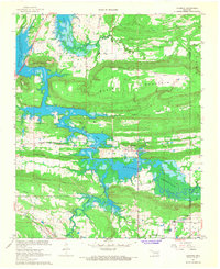
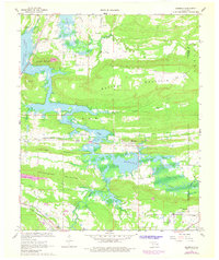
Eufaula Reservoir dominates the landscape of this 1960s survey, its waters reaching into the valleys between long, parallel ridges such as Buffalo Mountain and Fish Trap Mountain. The town of Adamson sits near the reservoir's edge, surrounded by evidence of an evolving transport network that includes the Old Railroad Grade and the Missouri Kansas Texas Railroad Grade. In the southern portion of the map, the Chicago Rock Island and Pacific railroad remains active, cutting through the terrain near Dow Lake.
Find a feature on this map
31 named features on this map. Tap any name to fly to it.
Don’t see what you’re looking for? This feature index may not catch every label — zoom into the map to look around manually.
Map Details
Editions of this 1967 Adamson Map
2 editions found
Other maps of this area

1898 · McAlester
USGS Topo · 1:125,000

1900 · Sansbois
USGS Topo · 1:125,000

1900 · Canadian
USGS Topo · 1:125,000

1901 · Tuskahoma
USGS Topo · 1:125,000

1908 · Tuskahoma
USGS Topo · 1:125,000

1909 · Mc Alester
USGS Topo · 1:125,000

1909 · Tuskahoma
USGS Topo · 1:125,000

1909 · Sans Bois
USGS Topo · 1:125,000

1911 · Sansbois
USGS Topo · 1:125,000

1946 · Fort Smith
USGS Topo · 1:250,000