1967 Map of Adamson
USGS Topo · Published 1978About this map
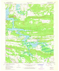
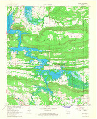
Buffalo Mountain and the surrounding ridgelines of Fish Trap Mountain and Pocahontas Mountain dominate the geography of this Choctaw Country landscape. The mapping reflects a significant era of transition as the waters of Eufaula Lake reach into the valleys of Gaines Creek and Brushy Creek, altering the local topography and creating the Hickory Point Recreation Area. Historic transportation corridors are clearly defined, including the Missouri Kansas Texas Railroad and the Chicago Rock Island and Pacific Railroad which once serviced the mining and agricultural interests of settlements like Adamson and Dow. For genealogists, the map preserves the locations of several rural centers of worship and burial, such as Cole Chapel Cem, Ash Creek Ch, and the landmark Jones Academy situated in the southern portion of the quadrangle.
Find a feature on this map
31 named features on this map. Tap any name to fly to it.
Don’t see what you’re looking for? This feature index may not catch every label — zoom into the map to look around manually.
Map Details
Editions of this 1967 Adamson Map
2 editions found
Other maps of this area

1898 · McAlester
USGS Topo · 1:125,000

1900 · Sansbois
USGS Topo · 1:125,000

1900 · Canadian
USGS Topo · 1:125,000

1901 · Tuskahoma
USGS Topo · 1:125,000

1908 · Tuskahoma
USGS Topo · 1:125,000

1909 · Mc Alester
USGS Topo · 1:125,000

1909 · Tuskahoma
USGS Topo · 1:125,000

1909 · Sans Bois
USGS Topo · 1:125,000

1911 · Sansbois
USGS Topo · 1:125,000

1946 · Fort Smith
USGS Topo · 1:250,000