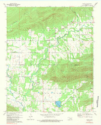
1971 Map of Yanush
USGS Topo · Published 1984About this map
The Old Choctaw Indian Council House anchors the southern portion of this landscape, reflecting the deep cultural significance of the Tuskahoma Valley during the early 1970s. This survey details a transitional area where Buffalo Valley meets the mountainous terrain of the Oklahoma interior, centered on the small settlement of Yanush. The map reveals a community defined by its cemeteries and rural institutions, such as King Cem, Hokit Cem, and Cupco Ch, scattered along the winding course of Buffalo Creek. A clear division is visible at the Latimer Co and Pushmataha Co boundary line, which separates the valley systems. Modern additions to the traditional agrarian landscape include the Four Star Ranch Landing Strip and the Picnic Area near Lake Nanih Waiya, illustrating how recreation and private aviation began to interface with established family farms like Terrylain Farm during this era.
Find a feature on this map
25 named features on this map. Tap any name to fly to it.
Don’t see what you’re looking for? This feature index may not catch every label — zoom into the map to look around manually.
Map Details
Editions of this 1971 Yanush Map
2 editions found
Other maps of this area

1901 · Tuskahoma
USGS Topo · 1:125,000

1908 · Tuskahoma
USGS Topo · 1:125,000

1909 · Tuskahoma
USGS Topo · 1:125,000

1940 · Red Oak
USGS Topo · 1:62,500

1943 · Red Oak
USGS Topo · 1:62,500

1950 · Mcalester
USGS Topo · 1:250,000

1962 · McAlester
USGS Topo · 1:250,000

1965 · McAlester
USGS Topo · 1:250,000

1971 · Yanush
USGS Topo · 1:24,000

1971 · Kiamichi
USGS Topo · 1:24,000