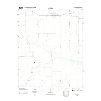
2012 Map of Quitaque
USGS Topo · Published 2012About this map
Quitaque serves as the central hub of this high plains landscape, situated at the intersection of Ranch Road 1065 and Ranch Road 599. The town's grid is clearly defined by streets such as Baird St and Jago St, reflecting its role as a regional service center for the surrounding ranchlands. To the east, the settlement of Gasoline appears near Kent Cr, while the southern reaches of the map are defined by the small community of Fairmont and the crossing of Quitaque Cr. The geography is etched by deep drainage systems including Pole Canyon and Long Hollow, illustrating the erosion patterns characteristic of the Caprock Escarpment region. Local history is anchored by the Rest Haven Cem near town and the more remote Gray Mule Cem situated near the Gray Mule settlement, marking the generational footprint of rural families.
Find a feature on this map
47 named features on this map. Tap any name to fly to it.
Don’t see what you’re looking for? This feature index may not catch every label — zoom into the map to look around manually.
Map Details
Editions of this 2012 Quitaque Map
This is the sole edition of this map. No revisions or reprints were ever made.
Other maps of this area

1954 · Plainview
USGS Topo · 1:250,000

1958 · Plainview
USGS Topo · 1:250,000

1967 · Quitaque
USGS Topo · 1:24,000

1967 · Quitaque Peaks
USGS Topo · 1:24,000

1967 · Edgemon Lake
USGS Topo · 1:24,000

1967 · Hay Lake
USGS Topo · 1:24,000

1967 · Flomot
USGS Topo · 1:24,000
1967 · Wilson Creek
USGS Topo · 1:24,000

1967 · Turkey
USGS Topo · 1:24,000

1967 · Lake Theo
USGS Topo · 1:24,000