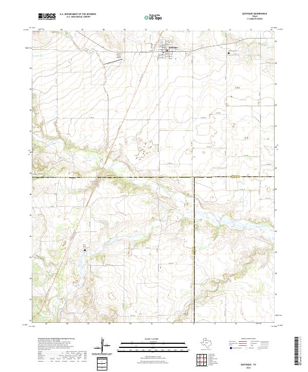
2022 Map of Quitaque
USGS Topo · Published 2022About this map
The town of Quitaque serves as a central hub in this corner of the Texas Panhandle, positioned where the high plains begin their descent into the rolling breaks. The landscape is defined by the convergence of several major drainage systems, including Los Lingos Cr and Quitaque Cr, which carve through the terrain to form landmarks like Pole Canyon. The map reveals a transition of political boundaries where Briscoe, Floyd, and Motley counties meet, illustrating the late-modern parceling of ranching and agricultural lands. Transportation is anchored by Ranch Rd 1065 and FM 599, while local aviation is served by Henson Farms Airport. For genealogists and local historians, the inclusion of Resthaven Cem near the town center and the more isolated Gray Mule Cem to the southwest provides critical touchpoints for tracing family lineages in this rural cattle-and-farming country.
Find a feature on this map
56 named features on this map. Tap any name to fly to it.
Don’t see what you’re looking for? This feature index may not catch every label — zoom into the map to look around manually.
Map Details
Editions of this 2022 Quitaque Map
This is the sole edition of this map. No revisions or reprints were ever made.
Other maps of this area

1954 · Plainview
USGS Topo · 1:250,000

1958 · Plainview
USGS Topo · 1:250,000

1967 · Quitaque
USGS Topo · 1:24,000

1967 · Quitaque Peaks
USGS Topo · 1:24,000

1967 · Edgemon Lake
USGS Topo · 1:24,000

1967 · Hay Lake
USGS Topo · 1:24,000

1967 · Flomot
USGS Topo · 1:24,000
1967 · Wilson Creek
USGS Topo · 1:24,000

1967 · Turkey
USGS Topo · 1:24,000

1967 · Lake Theo
USGS Topo · 1:24,000