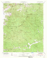
1946 Map of Rabun Bald
USGS Topo · Published 1970About this map
Rabun Bald dominates the high divide of the Blue Ridge, marking a significant topographical point in the transition between the Nantahala National Forest of North Carolina and the Chattahoochee National Forest in Georgia. This mid-century landscape is defined by its deep gaps and high knobs, where early mountain communities established themselves along the watercourses. Local life centers on settlements like Dillard and Mountain City, supported by the Tenn R R and the winding course of Warwoman Creek. The map records a network of family-named landmarks and rural institutions, including the Locust School and various burial grounds such as Hale Church Cem and Kelly Cem. Much of the southern portion is dedicated to the Warwoman Wildlife Management Area, reflecting the shift toward conservation and public forest management in the southern Appalachians during this era.
Find a feature on this map
75 named features on this map. Tap any name to fly to it.
Don’t see what you’re looking for? This feature index may not catch every label — zoom into the map to look around manually.
Map Details
Editions of this 1946 Rabun Bald Map
4 editions found
Other maps of this area

1886 · Walhalla
USGS Topo · 1:125,000

1891 · Cowee
USGS Topo · 1:125,000

1892 · Walhalla
USGS Topo · 1:125,000

1896 · Walhalla
USGS Topo · 1:125,000

1897 · Cowee
USGS Topo · 1:125,000

1907 · Cowee
USGS Topo · 1:125,000

1935 · Prentiss
USGS Topo · 1:24,000

1935 · Dillard
USGS Topo · 1:24,000

1935 · Scaly
USGS Topo · 1:24,000

1935 · Rabun Bald
USGS Topo · 1:24,000