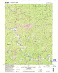
2000 Map of Racine
USGS Topo · Published 2001About this map
The Big Coal River and its many winding tributaries define the landscape of this Coal River Valley map, where the deep-cut topography of the Appalachian Plateaus dictates the pattern of settlement and industry. Long established communities like Peytona and Racine follow the river bends, while smaller hamlets such as Ashford, Nellis, and Brushton occupy narrow hollows. The industrial character of the era is evident through the numerous strip mines and gas wells scattered across the ridges, and the presence of a Gaging Station and Compressor Station.
Find a feature on this map
88 named features on this map. Tap any name to fly to it.
Don’t see what you’re looking for? This feature index may not catch every label — zoom into the map to look around manually.
Map Details
Editions of this 2000 Racine Map
This is the sole edition of this map. No revisions or reprints were ever made.
Other maps of this area

1899 · Charleston
USGS Topo · 1:125,000

1909 · Charleston
USGS Topo · 1:62,500

1909 · Peytona
USGS Topo · 1:48,000

1909 · Saint Albans
USGS Topo · 1:62,500

1911 · Peytona
USGS Topo · 1:62,500

1911 · Madison
USGS Topo · 1:62,500

1929 · Madison
USGS Topo · 1:62,500

1929 · Peytona
USGS Topo · 1:62,500

1931 · Madison
USGS Topo · 1:62,500

1931 · Saint Albans
USGS Topo · 1:62,500