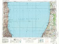
1958 Map of Racine
USGS Topo · Published 1984About this map
Lake Michigan dominates this regional survey, serving as the central link between the industrial lakefronts of Wisconsin, Illinois, and Michigan. Along the western shore, the corridor from Milwaukee down to Evanston is a dense network of residential and military sites, including the Great Lakes Naval Training Center and Fort Sheridan. The map details the complex rail infrastructure of the era, showing the Milwaukee Road and Chicago and North Western lines connecting lakefront cities like Racine, Kenosha, and Waukegan. Across the water, the Michigan shoreline presents a different character, defined by landforms like Van Buren Bluffs and Cedar Bluff, alongside extensive natural areas such as the Allegan State Game Area. Inland, numerous small lakes like Rush Lake and Hutchins Lake dot the Michigan landscape, providing a sharp contrast to the high-density urbanization of the western shore.
Find a feature on this map
197 named features on this map. Tap any name to fly to it.
Don’t see what you’re looking for? This feature index may not catch every label — zoom into the map to look around manually.
Map Details
Editions of this 1958 Racine Map
3 editions found

Other maps of this area

1889 · Chicago
USGS Topo · 1:62,500

1891 · Bayview
USGS Topo · 1:62,500

1891 · Chicago
USGS Topo · 1:62,500

1891 · Riverside
USGS Topo · 1:62,500

1891 · Muskego
USGS Topo · 1:62,500

1892 · Milwaukee
USGS Topo · 1:62,500

1892 · Waukesha
USGS Topo · 1:62,500

1892 · Racine
USGS Topo · 1:62,500

1893 · Riverside
USGS Topo · 1:62,500

1893 · Silver Lake
USGS Topo · 1:62,500