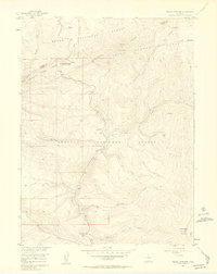
1956 Map of Radial Mountain
USGS Topo · Published 1957About this map
Willow Creek Pass marks a critical high-altitude junction in the mid-1950s where the Never Summer Range and Rabbit Ears Range meet. This survey documents the intersection of the Routt National Forest and Arapaho National Forest, a landscape defined by seasonal movement and federal land management. Evidence of forest infrastructure and early recreational access is clear at the Gilsonite Guard Station and established campsites like Trail Creek Campground and Denver Creek Campground. A network of unpaved transit routes, including the Willow Pass Trail and various Stock Drive paths, underscores the area's history as a corridor for livestock and backcountry travel. Names like Mutstay and the Road Camp near Snyder Creek reflect the sparse, functional settlement pattern of this high-country divide.
Find a feature on this map
29 named features on this map. Tap any name to fly to it.
Don’t see what you’re looking for? This feature index may not catch every label — zoom into the map to look around manually.
Map Details
Editions of this 1956 Radial Mountain Map
4 editions found
Other maps of this area

1915 · Longs Peak
USGS Topo · 1:125,000

1919 · Rocky Mountain National Park
USGS Topo · 1:125,000

1954 · Greeley
USGS Topo · 1:250,000

1954 · Craig
USGS Topo · 1:250,000

1956 · Radial Mountain
USGS Topo · 1:24,000

1956 · Jack Creek Ranch
USGS Topo · 1:24,000

1956 · Parkview Mountain
USGS Topo · 1:24,000

1956 · Rand
USGS Topo · 1:24,000

1956 · Rand
USGS Topo · 1:62,500

1957 · Craig
USGS Topo · 1:250,000