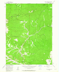
1956 Map of Radial Mountain
USGS Topo · Published 1963About this map
Continental Divide serpentines across the high ridges of the Rabbit Ears Range on this mid-century topographic survey, marking the jagged boundary between Routt National Forest and Arapaho National Forest. The landscape is dominated by a complex network of drainages including Willow Creek, Snyder Creek, and Denver Creek, which carve deep valleys between peaks like Radial Mountain and Little Gravel Mountain.
Find a feature on this map
28 named features on this map. Tap any name to fly to it.
Don’t see what you’re looking for? This feature index may not catch every label — zoom into the map to look around manually.
Map Details
Editions of this 1956 Radial Mountain Map
4 editions found
Other maps of this area

1915 · Longs Peak
USGS Topo · 1:125,000

1919 · Rocky Mountain National Park
USGS Topo · 1:125,000

1954 · Greeley
USGS Topo · 1:250,000

1954 · Craig
USGS Topo · 1:250,000

1956 · Radial Mountain
USGS Topo · 1:24,000

1956 · Jack Creek Ranch
USGS Topo · 1:24,000

1956 · Parkview Mountain
USGS Topo · 1:24,000

1956 · Rand
USGS Topo · 1:24,000

1956 · Rand
USGS Topo · 1:62,500

1957 · Craig
USGS Topo · 1:250,000