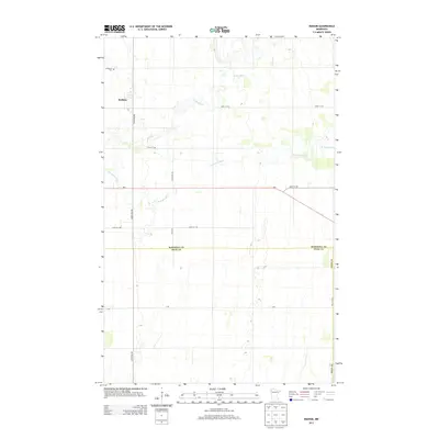
2013 Map of Radium
USGS Topo · Published 2013About this map
Radium serves as the focal point of this landscape in Northwest Minnesota, where the agrarian grid meets the meandering waters of the Snake River. Located near the border of Marshall and Polk Counties, the area is defined by its flat, expansive geography and a network of section-line roads like 260th Ave NW and 240th St NW. The S Br Snake River winds through the central and southern portions of the territory, providing a natural contrast to the rigid geometry of the surrounding fields. Local history is anchored at the Immanuel Cem in the northwest, while Mn-1 provides the primary east-west corridor for transportation and commerce across the southern reaches of the quadrangle.
Find a feature on this map
16 named features on this map. Tap any name to fly to it.
Don’t see what you’re looking for? This feature index may not catch every label — zoom into the map to look around manually.
Map Details
Editions of this 2013 Radium Map
This is the sole edition of this map. No revisions or reprints were ever made.
Other maps of this area

1918 · Angus
USGS Topo · 1:62,500

1918 · Viking
USGS Topo · 1:62,500

1952 · Thief River Falls
USGS Topo · 1:250,000

1956 · Thief River Falls
USGS Topo · 1:250,000

1956 · Florian
USGS Topo · 1:62,500

1957 · Thief River Falls
USGS Topo · 1:250,000

1957 · Newfolden
USGS Topo · 1:62,500

1959 · Viking
USGS Topo · 1:24,000
1959 · Viking SW
USGS Topo · 1:24,000

1961 · Radium
USGS Topo · 1:24,000