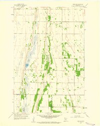
1959 Map of Viking SW
USGS Topo · Published 1960About this map
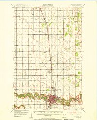
Goose Lake Swamp dominates the western half of this landscape, creating a distinct linear geography that transitions into the prairie farmlands of northwestern Minnesota. Small rural institutions such as the Black River Ch, an adjacent Cem, and School No 1560 dot the area near the winding Black River, representing the scattered nodes of the late 1950s rural community. This survey provides a precise view of the border region between Pennington and Polk counties, where the township boundaries of Numedal, Bray, Belgium, and Pok Centre meet. The land use is primarily agricultural, punctuated by a central Town Hall and occasional industrial sites like a Gravel Pit, reflecting a period when small-scale municipal and educational centers remained vital to the township structure before further rural consolidation.
Find a feature on this map
13 named features on this map. Tap any name to fly to it.
Don’t see what you’re looking for? This feature index may not catch every label — zoom into the map to look around manually.
Map Details
Editions of this 1959 Viking SW Map
This is the sole edition of this map. No revisions or reprints were ever made.
Other maps of this area

1918 · Angus
USGS Topo · 1:62,500
1918 · Red Lake Falls
USGS Topo · 1:62,500
1918 · Viking
USGS Topo · 1:62,500
1952 · Red Lake Falls
USGS Topo · 1:62,500

1952 · Grand Forks
USGS Topo · 1:250,000

1952 · Thief River Falls
USGS Topo · 1:250,000
1953 · Crookston
USGS Topo · 1:62,500

1956 · Thief River Falls
USGS Topo · 1:250,000

1956 · Grand Forks
USGS Topo · 1:250,000

1957 · Thief River Falls
USGS Topo · 1:250,000