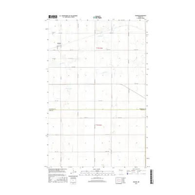
2016 Map of Radium
USGS Topo · Published 2016About this map
Radium serves as the primary landmark in this rural stretch of the Red River Valley, situated at the intersection of several county routes and local section roads. The landscape is defined by the winding course of the Snake River and its tributary, the S Br Snake River, which meander through the northwestern Minnesota prairie. The presence of Immanuel Cem northwest of the main settlement provides a specific point of interest for genealogists and local historians documenting early families in this agricultural region. This survey captures the precise boundary line between Marshall Co and Polk Co, illustrating the township-and-range grid system that governs the northern plains. The map traces a network of farm-to-market roads, including Co RD 111 and Co RD 35, which connect the scattered homesteads and fields to the central grain elevator and small-town hub of Radium.
Find a feature on this map
20 named features on this map. Tap any name to fly to it.
Don’t see what you’re looking for? This feature index may not catch every label — zoom into the map to look around manually.
Map Details
Editions of this 2016 Radium Map
This is the sole edition of this map. No revisions or reprints were ever made.
Other maps of this area

1918 · Angus
USGS Topo · 1:62,500

1918 · Viking
USGS Topo · 1:62,500

1952 · Thief River Falls
USGS Topo · 1:250,000

1956 · Thief River Falls
USGS Topo · 1:250,000

1956 · Florian
USGS Topo · 1:62,500

1957 · Thief River Falls
USGS Topo · 1:250,000

1957 · Newfolden
USGS Topo · 1:62,500

1959 · Viking
USGS Topo · 1:24,000
1959 · Viking SW
USGS Topo · 1:24,000

1961 · Radium
USGS Topo · 1:24,000