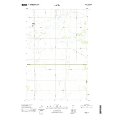
2019 Map of Radium
USGS Topo · Published 2019About this map
Radium serves as the central hub of this agricultural landscape in northwestern Minnesota, situated along Co Hwy 36 and Co Rd 35. The topography is defined by the winding paths of the Snake River and the S Br Snake River, which cut through the rectilinear grid of section lines and county roads. Near the settlement, Immanuel Cem remains a significant site for local family history and genealogy. The map also delineates the jurisdictional boundary between Marshall Co and Polk Co, a line that runs east-to-west across the lower third of the quadrangle. This area represents a classic prairie township structure, where the drainage of the Snake River system provides the only variation in an otherwise highly organized grid of farm roads and fields.
Find a feature on this map
28 named features on this map. Tap any name to fly to it.
Don’t see what you’re looking for? This feature index may not catch every label — zoom into the map to look around manually.
Map Details
Editions of this 2019 Radium Map
This is the sole edition of this map. No revisions or reprints were ever made.
Other maps of this area

1918 · Angus
USGS Topo · 1:62,500

1918 · Viking
USGS Topo · 1:62,500

1952 · Thief River Falls
USGS Topo · 1:250,000

1956 · Thief River Falls
USGS Topo · 1:250,000

1956 · Florian
USGS Topo · 1:62,500

1957 · Thief River Falls
USGS Topo · 1:250,000

1957 · Newfolden
USGS Topo · 1:62,500

1959 · Viking
USGS Topo · 1:24,000
1959 · Viking SW
USGS Topo · 1:24,000

1961 · Radium
USGS Topo · 1:24,000