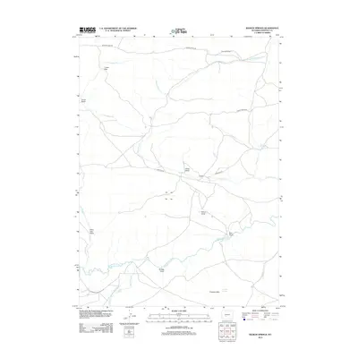
2012 Map of Radium Springs
USGS Topo · Published 2012About this map
The Oregon Trl cuts across this high desert landscape, marking the enduring path of westward migration through Fremont County. The map details a transition from historical transit to modern ranching and resource management, anchored by the Sweetwater River in the south and the small settlement of Lewiston. Water management is central to the area's geography, evidenced by features such as Harris Ditch and Harris Slough, which support the arid grasslands. To the north, the Rate Homestead and Crows Nest suggest the dispersed nature of human habitation in this terrain. The eastern portion of the sheet is defined by the Antelope Hills and the namesake Radium Springs, while numerous drainages like Giblin Gulch and Wilson Gulch carve the upland plateau between the river and the northern ranch roads.
Find a feature on this map
28 named features on this map. Tap any name to fly to it.
Don’t see what you’re looking for? This feature index may not catch every label — zoom into the map to look around manually.
Map Details
Editions of this 2012 Radium Springs Map
This is the sole edition of this map. No revisions or reprints were ever made.
Other maps of this area

1953 · Lewiston Lakes
USGS Topo · 1:24,000

1953 · Gravel Spring
USGS Topo · 1:24,000

1953 · Radium Springs
USGS Topo · 1:24,000

1953 · Schlichting Mountain
USGS Topo · 1:24,000

1953 · Atlantic City
USGS Topo · 1:24,000

1954 · Miners Delight
USGS Topo · 1:24,000

1955 · Lander
USGS Topo · 1:250,000

1958 · Lander
USGS Topo · 1:250,000
1958 · Schoettlin Mountain
USGS Topo · 1:24,000

1958 · Circle Bar Lake
USGS Topo · 1:24,000