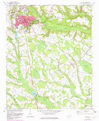
1972 Map of Raeford
USGS Topo · Published 1983About this map
Raeford serves as a significant rail and administrative hub in this early 1970s survey, defined by the junction of the Southern and the Aberdeen And Rockfish railroads. The town’s core is densely detailed, featuring the Courthouse, Armory, and McLaughlin Sch, while the surrounding landscape is a complex network of wetlands and small agricultural communities. The southern and eastern portions of the map are dominated by the winding paths of Raft Swamp, Middle Swamp, and Big Marsh Swamp, which dictate the placement of rural settlements like Dundarrach and Antioch.
Find a feature on this map
50 named features on this map. Tap any name to fly to it.
Don’t see what you’re looking for? This feature index may not catch every label — zoom into the map to look around manually.
Map Details
Editions of this 1972 Raeford Map
3 editions found
Other maps of this area

1948 · Southern Pines
USGS Topo · 1:62,500

1948 · Clifdale
USGS Topo · 1:62,500

1948 · Nicholson Creek
USGS Topo · 1:24,000

1948 · Clifdale
USGS Topo · 1:24,000

1948 · Mc Cain
USGS Topo · 1:24,000

1949 · Wagram
USGS Topo · 1:24,000

1949 · Wakulla
USGS Topo · 1:24,000

1949 · Laurinburg
USGS Topo · 1:62,500

1950 · Clifdale
USGS Topo · 1:24,000

1950 · Sanatorium
USGS Topo · 1:24,000