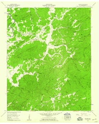
1957 Map of Rafter
USGS Topo · Published 1959About this map
The Cherokee National Forest dominates this mid-century survey of Monroe County, revealing a landscape defined by sharp ridges and narrow creek bottoms. In the northern reaches, the community center around Tariffville is anchored by the Ebenezer Ballplay Ch and Ballplay Sch, reflecting the importance of rural social hubs in this period. The terrain is marked by family-named heights such as Birchfield Mountain and Lynn Carden Mtn, while the western edge follows the course of the Tellico River near Tellico Ch. To the south, the settlement of Rafter sits near Friends Ch, surrounded by the Tellico Wildlife Management Area. The map captures an era of established forest management, where many small homesteads and local landmarks like Shaw Camp remained accessible via a network of secondary roads and trails through Huckleberry Ridge.
Find a feature on this map
63 named features on this map. Tap any name to fly to it.
Don’t see what you’re looking for? This feature index may not catch every label — zoom into the map to look around manually.
Map Details
Editions of this 1957 Rafter Map
4 editions found
Other maps of this area

1893 · Murphy
USGS Topo · 1:125,000

1895 · Loudon
USGS Topo · 1:125,000

1914 · Murphy
USGS Topo · 1:125,000

1927 · Big Junction
USGS Topo · 1:24,000

1933 · Haw Knob
USGS Topo · 1:48,000

1933 · Whiteoak Flats
USGS Topo · 1:24,000

1933 · Bald River Falls
USGS Topo · 1:24,000

1933 · Rafter
USGS Topo · 1:24,000

1934 · Mount Vernon
USGS Topo · 1:24,000

1934 · Tellico Plains
USGS Topo · 1:24,000