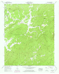
1957 Map of Rafter
USGS Topo · Published 1978About this map
Cherokee National Forest dominates this topographic survey of the Monroe County backcountry, where the Tellico River flows past Tellico Ch and under the shadows of Turkeypen Mountain. The landscape is defined by the steep ridges of Red Mountain and Miller Ridge, punctuated by high points like Peaky Top. Small settlements and social centers are tucked into the valleys, including the community of Rafter near Friends Ch and the northern pocket of Tariffville along Tanyard Branch.
Find a feature on this map
64 named features on this map. Tap any name to fly to it.
Don’t see what you’re looking for? This feature index may not catch every label — zoom into the map to look around manually.
Map Details
Editions of this 1957 Rafter Map
4 editions found
Other maps of this area

1893 · Murphy
USGS Topo · 1:125,000

1895 · Loudon
USGS Topo · 1:125,000

1914 · Murphy
USGS Topo · 1:125,000

1927 · Big Junction
USGS Topo · 1:24,000

1933 · Haw Knob
USGS Topo · 1:48,000

1933 · Whiteoak Flats
USGS Topo · 1:24,000

1933 · Bald River Falls
USGS Topo · 1:24,000

1933 · Rafter
USGS Topo · 1:24,000

1934 · Mount Vernon
USGS Topo · 1:24,000

1934 · Tellico Plains
USGS Topo · 1:24,000